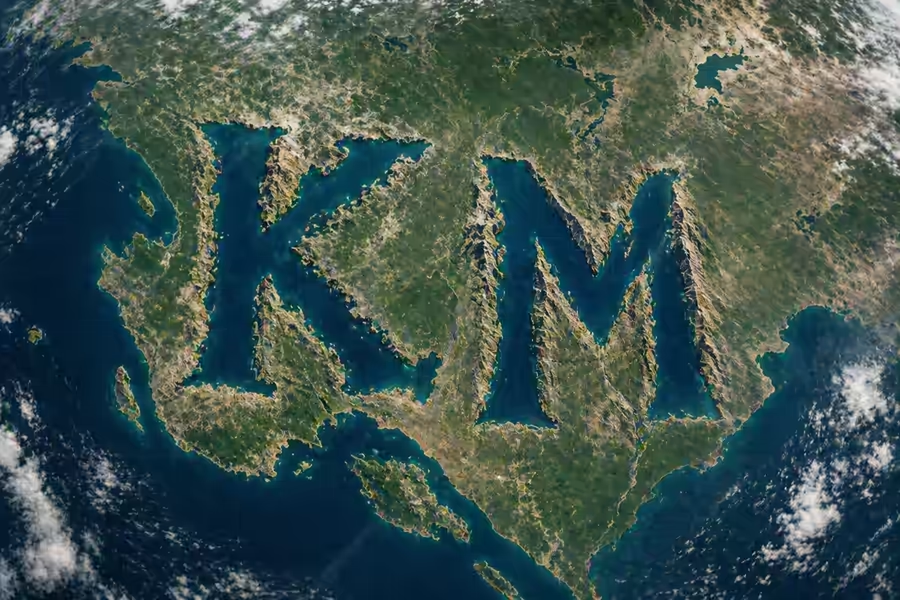
NASA has introduced a new interactive experience that transforms decades of satellite data into a creative social experience. The application enables individuals to find out their names in the form of actual pictures of the terrains on Earth taken by spacecrafts.
The site, named Your Name in Landsat, is based on satellite imagery to pair each letter of a word with a natural feature such as rivers, coastline, mountain and desert that take the shape of an alphabet. The outcome is a customised image that is wholly comprised of the real-life geography.
How the Tool Works
The instrument is constructed on the Landsat program data, which is an extensive partnership between the NASA and the US Geological Survey. Landsat satellites have been used to provide detailed images of the surface of the earth since 1972.
With such a large collection, the system recognizes trends in the landscapes resembling letters. Upon typing a name, the tool will select the relevant satellite images and construct them to create each letter in a graphic format.
The Science behind the Feature
The tool may look easy but it operates using sophisticated remote sensing. Landsat satellites reflect light bounced off the earth at various wavelengths, which enables scientists to study the land surfaces in details.
This information is extensively employed to monitor:
- Land use and urban growth.
- Forest cover and environment wellbeing.
- Climate impact and movement of glaciers.
- Water bodies and agriculture.
They are now using the same scientific data to produce an engaging public tool.
The importance of Landsat
According to NASA, Landsat mission is the gold standard in monitoring the land surface of the earth. It has earned itself one of the longest histories of environmental transformation on Earth, over a period of over 50 years.
This information assists governments, researchers and organisations to make resource management, climate policy and environmental protection decisions.
Name Making
The users are able to create their own satellite-based name design easily:
- Go to the official Your Name in Landsat Web Site.
- Search by typing in A-Z letters your name or any word.
- Name Submit to create a satellite version of your name.
- Revise to alternate versions.
- Download or share the end result.
Every effort can result in a new mix of scenery, and such an experience can always be unique.
A combination of Science and Imagination
The tool demonstrates how complicated satellite data can be turned into something easy to understand and engage with. It comes as a new means in which human beings can relate to the Earth observation besides demonstrating the magnitude and the clarity of images taken in space.
NASA has been able to access decades of research information by merging science and creativity to make it both informative and entertaining to the general population.
Also Read: